As the 2017 hurricane season comes to a close we can obviously look back at landfalling droughts ended and records broken. But what can we take from this year's Atlantic Hurricane season and its associated systems forward into how we think about hurricane risk and how we might improve on modelling it? Here are a few points that have sprung to mind this season. It's purely a point of view, but hopefully something to chew over.

1) How do we model hurricanes in a warming environment?
The chart here shows the last 30 years of the average sea surface temperatures in September stretching across the Atlantic at 20 degrees north. You can see the gradual warming throughout this period, which may (or may not) be attributable to the Atlantic Multidecadal Oscillation.
Read most documents looking at model projections in our the alleged anthropogenically-warmed climate around hurricanes and the message is fairly consensual for the future: potentially fewer hurricanes / hurricane landfalls, but an increase in the more intense hurricanes.
What's interesting is that if we take a look back at 2004-2017 as a whole, it almost seems that there is the hallmark of these prognostications in the data presented to us. Yes, the sample size is small, but we've had 11 years with precious few landfalling storms, and 2017 has produced some remarkable statistics [longest lived, further east] around category 5 storms to go alongside the busy landfalling seasons of 2004 and 2005.
I feel we should be expending more energy on working out what's happening now - and partnering with academia - who naturally are the specialists in this topic with the computing power to be able to help us answer this. A few of the questions that might seem sensible trying to answer that feed back into hurricane frequency in our catastrophe models are:
Was the 2006-2016 "quiet" period most likely a statistical anomaly or something with a physical (and climate-warming forced) explanation that we should therefore be capturing in risk models?
Does the current warmer phase of the ocean feed back into changes where hurricanes can form and how they move?
Can we get a feel for whether the AMO (if it exists) and its associated warm SSTs will be with us for another 5,10,20 years from short-term, high-resolution climate/ocean modelling?
....rather than finding new ways to dissect the HURDAT datasets that seem only to increase our knowledge iteratively by a small amount each year with each year's new data.
As I've said before on this blog, I feel climate models are the key to helping us understand much more about our current climate. You will hear rightly that most climate models are run at a resolution that are not able to resolve the full detail of hurricanes. However, they can inform us about the large-scale environment that moves these tropical systems around (which is so key to landfall) and also in turn how the larger scale environment is affected by global scale (e.g. El Nino/La Nina) phenomena.
2) Should we be concerned about Ophelia-type storms?
Some nine hours before Hurricane Ophelia made landfall, she was still a tropical system. Nothing remarkable, but when the landfall is Ireland then it makes this meteorologically a lot more interesting, even if Ophelia's losses did not amount to a particularly great deal in a year of much more sizeable losses. The chart below shows the frequency of 85 kt tropical systems across the N Atlantic to show how anomalous this storm was:

The extent to which Ophelia was still being analysed tropical (and still evidently had a fairly warm core, typical of tropical systems) within nine hours of landfall was remarkable.
I feel we need some focused research into understanding tail risk in overlapping hurricane/extratropical cyclone seasons. It may seem fairly far-fetched to get a hurricane or reinvigorated extra-tropical cyclone through ex-tropical warm air interacting with the jet-stream: but isn't our industry here to ensure our risk-takers understand better and are able to capture better the "far-fetched" scenarios?
Also: would all European insurance contracts cover a landfalling hurricane?
3) Correlating flood and hurricanes
The warning shots were fired in 2001 when Tropical Storm Allison dragged its heels over Texas and deposited around 40 inches of rain in places. We had almost a repeat in 2017: only more severe. Dying tropical storms will wind down and produce minimal wind risk after a day or so after landfall. However, the trouble comes when they are slow-moving and often have a remnant circulation that can gently drag warm air and thunderstorms off the sea: especially in the south of the US where Gulf of Mexico seas are typically very warm during the hurricane season. The combination of the low pressure and the warm seas leads to intense convective rainfall.
We're in an era now where the private insurance market is starting to move in the US and for those taking on this risk, I would think that having modelling suites that have integrated flood and hurricane models (i.e. both informed by the hurricane event-set) is a necessity: we've had two major flood events in Texas alone in the past 16 years that wouldn't have happened were it for dying hurricanes. At the excellent flood model comparison study hosted by Lloyd's of London and Argo, of the attendant modelling companies, KatRisk and CoreLogic currently offered this. I would imagine (and definitely hope) the other vendors will follow suit. They just have to find a way to ensure that the frequency of tropical storms are modelled as well as they do for hurricane: tropical storms are often trimmed out of hurricane models given their relative impotence from the wind risk side.
4) Hyperbole and mis-attribution
Can we please stop blaming climate change the moment a meteorological disaster happens? Understanding the role of climate change and its impact on an event is very involved to work out in isolation directly post-event.
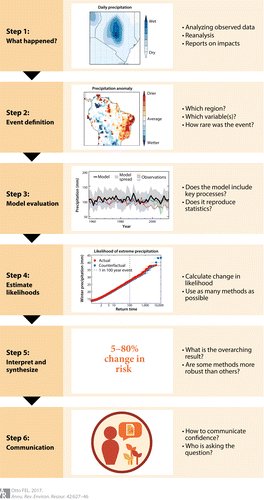
Was the sea slightly warmer because of climate change? Was the wind shear slightly higher? Was the storm track slightly further south than it might have been 50 years ago? In order to do the post-event forensics, often we need, for example, to re-simulate the event in pre-warming conditions, and that sort of thing takes a while to understand. This is beautifully demonstrated in a chart shown on Twitter last week by Dr Friederike Otto of the Environment Change Institute that shows the steps required in attribution studies before conclusions can start to be drawn.
Please: put the science before the desire for "clickbait".
This post originally appeared on the Simplitum/Nasdaq ModEx blog.