Hurricane Irma: thoughts ahead of a possible Florida landfall
- Richard Dixon

- Sep 7, 2017
- 3 min read
Irma is breaking records all over the place and leaving near-total damage in its wake: but I will leave that for others to discuss. As Irma heads towards the US Coastline, I wanted to post a short note on the uncertainty that seems to have dragged on in last 2-3 days around just what might be in store plus another couple of aspects of the storm that give maybe some context to the bigger picture of hurricane activity.
Uncertainties in Irma's future position
The animation below shows pretty well the problem we have. It shows the wind just above the surface and the central pressure field of Irma for Monday midnight from models run Thursday midnight. The models remain in disagreement around just whether Irma will make a Florida landfall in the densely populated Tri-counties region of Florida [Source: the superb Tropical Tidbits site]

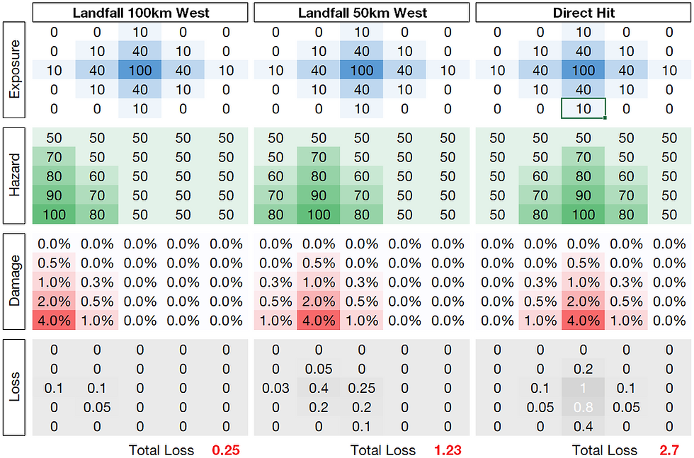
Actually, the models are performing pretty well: this sort of difference of around 50 miles difference in the location of a system from a 4-day forecast is impressive. Unfortunately those 50 km represent the difference probably between
- something like 70-90 mph winds in the Tri-counties if the hurricane stays off land (GFS model)
- maybe 150+ mph from the eyewall of the hurricane making landfall (ECMWF model)
The hurricane is due to make a fairly sharp northerly turn from its west-northwestward path through the Caribbean, and the uncertainty around when this will occur obviously impacts where landfall will happen. I suspect this uncertainty will linger until the turn actually happens, assuming it does.
Possible Impacts
Whereas publishing loss estimate at this early stage would be churlish, there is nothing wrong with the curiosity of understanding losses from perfectly feasible scenarios. RMS have done an excellent bit of work in the last day using the cone of uncertainty to produce some probabilistic estimates of where the loss could go. It's not a set of likely tracks, more a guide of what could happen.
Just to highlight the potential, I've taken a map of the forecast peak gusts from above ECMWF run that makes landfall in Tri-counties region but rather crudely sat this alongside the population density of Florida. The scale on the chart is in the maybe less-familiar knots to some so I've drawn some crude mph contours on the peak gust chart.

You only need to see colocation of the 120 mph contour and very high population density in SE Florida to understand the potentially sizeable losses this ECMWF realisation could produce. This isn't scaremongering: this is a possible scenario. I'm grateful to Ryan Maue for the ECMWF wind footprint here.
Irma's "unusual" strength
The chart below is something I created just to help myself understand how unusual Irma's strength for its location. It shows - in 2x2 degree latitude/longitude boxes - the location of storms in the Atlantic Basin that have reached 185 mph strength. The green box on the chart is where Irma (roughly) reached 185 mph for the first time: so much further east than prior instances of this windspeed:

This is so anomalously far east it did get me thinking about the bigger picture of warming seas that I'd referred to prior to the start of this hurricane season in another blog post. The chart I've plotted below shows a index of area of sea surface temperatures greater than 28c (a decent warm sea that can sustain a hurricane - maybe not a major hurricane, however) averaged across Septembers going back to 1900 (with the obvious caveats of data quality as one goes back through time):

The very basic message here is how the area of warm seas has been steadily increasing since the mid 1970s and we're left with an area in the current warm sea phase that is probably 50 larger than the 1950s. This is a very simple diagram but it illustrates the point that we could be seeing a wider area of seas that could support really intense hurricanes, so maybe Irma's intensity so far east should be less of a shock than it was?
It remains to be seen whether Irma hits Florida but what we've seen from Irma - and Harvey preceding her - has given me plenty of food for thought on hurricane activity and how we might want to understand it better in representing it in cat risk models: I'm sure I will post about this more in future.


Comments